


Wifi Collector

Wifi Collector açıklaması
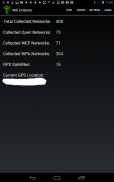
Eğer sokakta yürürken ya da araba sürüş yaparken bu uygulama kablosuz ağlar ve konumu hakkında bilgi toplar.
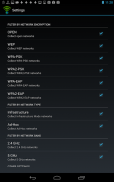
Her kablosuz ağ için, aşağıdaki bilgiler toplanır: erişim noktası, sinyal seviyesi, kanal frekans, kanal sayısı, güvenlik (WEP/WPA/WPA2), WPS imal erişim noktası, şirketin ağ adı (SSID), MAC adresi desteği (Evet / Hayır), ağ tespit ve kablosuz ağ (Boylam ve Enlem) konumu GPS çekildiği Tarih / Saat.
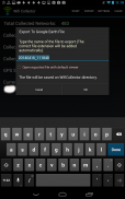
Kablosuz ağlar bilgi topladıktan sonra, csv dosyası, sekme ayrılmış dosya, HTML dosyası veya Google Earth bir harita üzerinde tüm toplanan ağların yerini görmek için izin Google Earth'ün. Kml dosyasına verebilirsiniz.
Bu uygulama WiFi bileşen ve GPS hem de bir aygıtı gerektirir.
Uyarı!
Bu uygulamayı kullanırken, pil normalden çok daha hızlı drene edilecek böylece bu uygulama ile GPS ve wifi bileşenin hem kullanımı oldukça yoğundur. Eğer wifi bilgi toplama bitirmek istediğinizde Durdur düğmesini tıklatın unutmayın.
Wifi Collector - Sürüm 1.03
(13-04-2019)
Wifi Collector - APK Bilgisi
APK sürümü: 1.03Paket: net.nirsoft.wificollectorWifi Collector uygulamasının en son sürümü
Diğer sürümler


Aynı kategorideki uygulamalar

Hoşuna gidebilecekler...


